The Whole Globe

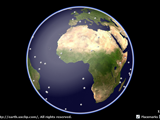
The Whole Globe is a compact 3D Earth viewer designed for Microsoft® .NET Framework for Silverlight®. Prospect the planet and find possibilities of visualization of information distributed all over the world within a built-in 3D viewer featuring freely-rotatable texture-mapped* earth model.
* The full colored texture image is the
"Blue Marble : Land Surface, Shallow Water, and Shaded Topography"
from NASA Goddard Space Flight Center by Reto Stöckli et al.
You can see the original equirectangular projection image at http://visibleearth.nasa.gov/.
* Microsoft and Silverlight are either registered trademarks or trademarks of Microsoft Corporation in the United States and/or other countries.
Some Features
- Texture-mapped, smooth-faced spherical 3D model of the Earth
- Intuitive mouse controls for geodetic-rotation and point-zooming
- Realtime detection of geographical coordinates by mouse hovering
- Three dimensional overlay of visual elements usable for visualization
How-to-Control-the-Earth Instructions
After a while with preloading process, the 3D Earth model comes into the screen and viewer gets ready. The model and/or the camera in the viewer can be controlled via either mouse or keyboard actions as follows.
Control the Earth by mouse: To rotate the Earth, mouse-drag-and-drop on the screen. In this viewer, the Earth's axis is not fixed at all. Therefore you can freely rotate the spherical model along arbitrary geodesic lines. To zoom the camera, mouse-wheel on the screen. By wheeling with mouse-pointer placed on some target point on the surface, you can zoom view directly toward that point.
Control the Earth by keyboard: Use arrow keys for rotation. And use +/- keys for zoom.
Optionally, you can change visual effects by the checkboxes at the bottom-right corner, such as [1] pseudo-shading (simulating diffusive + specular scattering), [2] atomosphic scattering around the edge of the globe and [3] texture image type (bicolored or fullcolored).
Placemarks

When you have "Placemark" checkbox marked, randomly distributed dot-marks (100 points) appear on the surface. The sample above demonstrates minimal user-interactions with placemarks; By hovering the mouse pointer over one of them, a tooltip simply popups to inform you of the latitude and longitude at the point.
Frequently Asked Questions
*If you have questions to be put here, please write an email to the contact address through "feedback" link in the footer of this web-page.